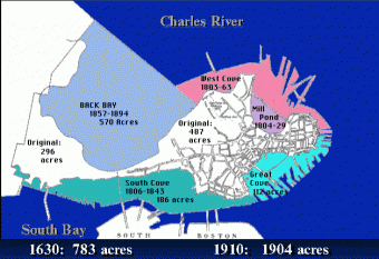
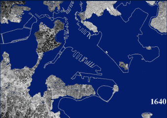
Did you know that since the 1600s over 1100 acres of land have been added by filling in marshes and redistributing dirt from hills in order to make land? This makes Boston a perfect example of learning how maps change because it’s not just political boundaries that have expanded. Even for the youngest learners like my preschooler, it makes a fun map unit and even more fun if you live or are visiting the area to do field trips.
Affiliate links included for reference and your shopping convenience.
How Boston’s Map has changed over time
Boston itself used to be on a thin peninsula.
Over time Boston has incorporated surrounding cities.
The edge of Boston Common used to be under water.
Read more, see full-size images, and get detailed information on Boston College’s History of the Boston Landfills
Ways you can study this change on maps with your kids
- Buy or print a map of Boston and gather up several different colors of play-doh. In fact, if you get a 20 color pack of play doh, you can easily distinguish between changes over time.Take your map and add original Boston. You can even add things like elevation for the hills and take away from them over time as you talk about building the peninsula outwards.
- Set up a scenario outside with some dirt hills, something to represent water, and a boundary drawn with powdered chalk. Have them problem solve different ways to increase and expand their borders.
- Similarly, you can also set this up with multiple kids (and it’s a better way to do it) where they’re all neighboring cities and they have to try to expand their borders. Doing a mini city project with them, they have to learn to work together, negotiate, etc. and maybe they’ll even come to the conclusion to incorporate to expand their borders mutually.
We looked for signs of land built out into the harbor and ocean together on the Boston Harbor Cruise
Field trip guide to learn about how maps change and how Boston’s perimeter has morphed over time
If you’re talking to your toddlers, preschoolers, and young kids, it’s important to first have an understanding of what a map even is. So the perfect first stop is at the Mapparium at the Mary Eddy Baker Library. With an amazing walk-through globe, it’s a fun place to start your map unit journey.
After that, head to the Boston Public Library in Copley Square. They have many map resources there including both a Map Room for kids and a coffee shop with maps on the walls. Look through Atlases and maps in the Map Center. In the map room behind the open courtyard, you will even find an exhibition with maps geared towards kids (even fictional ones).
The two most important things in this room, however, are the map of old Boston with new Boston drawn as an overlay and also the activity books you can pick up. See an online version of this map here.
These booklets help show each major change to Boston’s boundaries and is something we went through together with my three year old. We also really enjoyed talking about what was under water a long time ago but was now a station on the MBTA.
Next, take the Freedom Trail Trolley Tour with Boston Harbor Cruise. On the cruise, they even talk about how land was brought in to build up the surrounding area and point out what to look for and how the harbor has changed over time.
This reinforces what your child has learned from the map rooms and your conversations about how the map has changed.
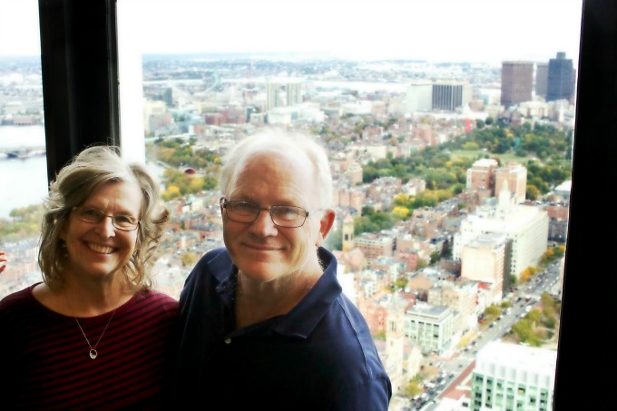
We visited the Skywalk Observatory with my parents (pictured) and spent an hour pointing out parts of the city together.
Go to the Top of the Prudential Tower. In the Skywalk observatory you can now help your child visualize what was under water and what it is now. Also, this trip is more than just going up into the tower. At the top, they have some mini exhibits up there including a timelines of events and informational chronicling how they took dirt from the hills and transported it out, filling in marshes to expand the city.
Find more ways you can learn about maps with your kids
Find the Letter C is for Compass from 3 Boys and a Dog
Build Excitement for a Disneyland Vacation from Crafty Mama in ME
How Maps Change Case study: Boston’s Boundaries over time from Boston Kid Friendly
How Kids Can Create Sketch Maps for the Outdoors from FrogMom
Map Books for Young Explorers from Brain Power Boy
Map Skills for Kids from Schooling a Monkey
Map Books for Children: Intro to Maps from The Jenny Evolution
Continents and Countries Olympic Sort from Planet Smarty Pants
Maps Unit for Preschoolers from Bambini Travel
3 Free Puzzles to Make Learning the Continents Fun from Books and Giggles
Geocaching for Kids from Parenting Chaos
Map Activities for Kids: France, England, Ireland {Printables} from The Natural Homeschool
Travel Maps for Kids from Craft Create Calm
Types of Maps from Soil & Water Conservation District from Something 2 Offer
Around the World Fun for Kids: Exploring Architecture from Artsy Momma
Using Maps as an Idea for Art Projects from Our Daily Craft
Making a Salt Dough Map from Tales of Education at Home

[…] How Maps Change Case study: Boston’s Boundaries over time from Boston Kid Friendly […]